A Case Study on Byzantine Macedonia (13th/14th Centuries)
![]()

Abstract
This article focuses on the borders of the Byzantine Empire in medieval South-East Europe, namely in pre-Ottoman (i.e. Byzantine) Macedonia. Far-reaching political changes occurred in the Southern Balkan Peninsula from the end of the 13th until the middle of the 14th century, when the Serbian medieval kingdom expanded to the South under the king Stefan Uroš II Milutin at the expense of the Byzantine Empire, which lasted until 1355. This again had a severe impact on the border zones and cross-border societies between both realms in Byzantine Macedonia in the same period. Medieval written sources, mainly Serbian and Byzantine charters, form the initial point of research. The sources are analysed based on the methods deriving from Historical Geography and regarding potential structures of local or supra-regional power. Moreover, tools from Digital Humanities in mapping and visualisation are applied in order to communicate the achieved results to the interested public.
Abstract (German)
Dieser Beitrag beschäftigt sich mit den Grenzen des Byzantinischen Reiches im mittelalterlichen Südosteuropa, genauer im vor-osmanischen (d. h. Byzantinischen) Mazedonien. Weitreichende politische Veränderungen traten auf der südlichen Balkanhalbinsel vom Ende des 13. bis zur Mitte des 14. Jahrhunderts ein, als sich das serbische mittelalterliche Königreich unter dem König Stefan Uroš II. Milutin auf Kosten des Byzantinischen Reiches nach Süden ausbreitete, was bis 1355 anhielt. Dies wiederum wirkte sich auf die Grenzräume und grenzübergreifenden Gesellschaften zwischen beiden Reichen im Byzantinischen Mazedonien aus. Den Ausgangspunkt der Forschung bilden die mittelalterlichen schriftlichen Quellen, vor allem serbische und byzantinische Urkunden. Die Quellen werden mit Methoden der Historischen Geographie analysiert und in Hinblick auf lokale bzw. überregionale Machtstrukturen interpretiert. Darüber hinaus werden Methoden aus den Digitalen Geisteswissenschaften (Digital Humanities) in der kartographischen Darstellung und Visualisierung eingesetzt, um die erzielten Forschungsergebnisse der interessierten Öffentlichkeit zu vermitteln.
Table of contents
Introduction
In the present article we are sharing some ideas and thoughts on “Patterns of Power” in Byzantine Macedonia from 1282 to 1355. Central questions of our research agenda include the correlation between space and power and thus, amongst others, the following research questions: How can we identify “Patterns of Power” in the landscape and how are they characterised? How can we interpret them concerning appropriation of power, its retention and transfer, its representation as well as the loss of it?
Our research combines written and archaeological evidence on physical entities (i.e. settlements, monuments, fortresses, even entire landscapes etc.), events and involved actors and investigates the respective interconnections. One important goal of this approach is to shed light on the various levels of the observed “Patterns of Power” by investigating the assemblage of these elements in time and space. The perception, depiction and organisation of spaces and places in the Middle Ages encompass an interdisciplinary research field, which helps us to understand historical processes and relations. However, traditional representations of space like paper maps often fail to capture the complex and dynamic nature of spaces and places. Digital tools allow more dynamic and multi-scale representations of historical space and spatial phenomena and relations.
Since the notion of “Patterns of Power” has been discussed several times with interest at conferences in the wake of our scholarly papers, we deem it necessary to elaborate in our following contribution, in which way we define “Patterns of Power” and / or “Signs of Power” and also what kind of source-based examples we encounter in Byzantine Macedonia from 1282 to 1355.
Moreover, we address the issue of the digital processing and storage of the related data as well as its visualisation for the interested public, which is based, on the one hand, on scholarly research conducted within the digital cluster project “Digitising Patterns of Power (DPP): Peripherical Mountains in the Medieval World” (in the following: DPP) at the Institute for Medieval Research of the Austrian Academy of Sciences in Vienna and, on the other hand, is deepened as well as expanded within a recently approved FWF Austrian Science Fund Project P 30384-G28 “Byzantino-Serbian Border Zones in Transition: Migration and Elite Change in pre-Ottoman Macedonia (1282-1355)”. The latter is conducted by Mihailo St. Popović as Project Leader with two scholarly co-workers, namely Vratislav Zervan, MA PhD and Bernhard Koschicek, BA BSc, is hosted at the Division of Byzantine Research of the Institute for Medieval Research of the Austrian Academy of Sciences and is at the same time a subproject of the Long-Term-Project Tabula Imperii Byzantini (TIB).
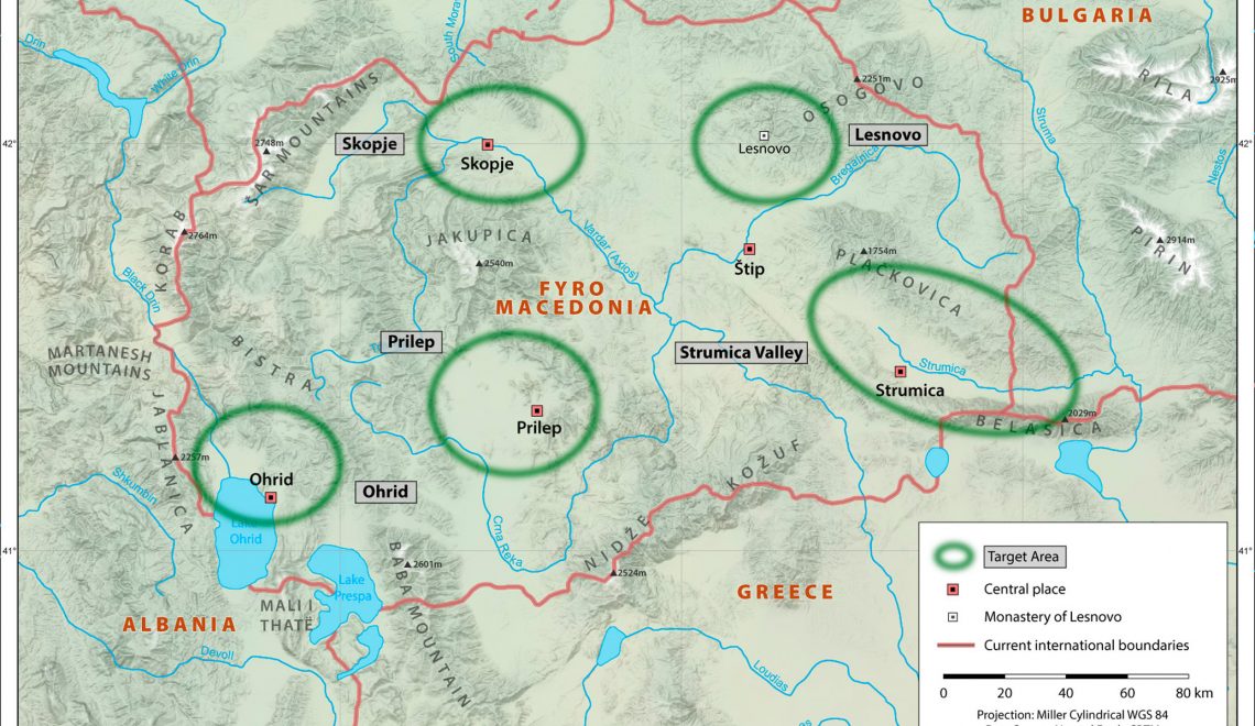
Our first and foremost aim during the first two years of DPP (i.e. in 2015 and 2016) has been to research, evaluate and input as much relevant data as possible into our DPP OpenAtlas Database. In our case study within DPP, which is entitled “The Historical Region of Macedonia (12th-14th Centuries) – The Transformation of a Medieval Landscape”, the respective data was and is extracted from medieval Byzantine and Serbian charters in the aforesaid period of time. Within DPP as well as the project “Byzantino-Serbian Border Zones in Transition” we are conducting research in depth on five target areas in Byzantine Macedonia, i.e. the regions of Skopje, Lesnovo, Strumica, Prilep and Ohrid (fig. 1).
-
- Fig. 1: The Five Target Areas of the Project “Byzantino-Serbian Border Zones in Transition”, Design: Mag. Markus Breier.
These areas have been carefully selected due to the fact that they represent zones of conflict and of interaction between the Byzantine Empire and the medieval Serbian kingdom from 1282 to 1355. This interaction is, amongst others, mirrored in the charters issued by the Byzantine Empire and the medieval Serbian kingdom for the same border zones or zones of conflict. Therefore, they represent a remarkable object for scholarly research from a historic and a linguistic point of view. Regarding the aforesaid five target areas we have evaluated 38 charters so far.
The respective source-based data was structured according to the five entities in our DPP OpenAtlas Database, which are as follows: Source, Event, Actor, Place and Reference. Since the aim of DPP and the project “Byzantino-Serbian Border Zones in Transition” is to put a clear cut emphasis on the research of the historical geography of Medieval Europe, our data input is focused on the entity Place within our DPP OpenAtlas Database. Thus, we have embedded and stored 390 places for the case study on medieval Macedonia until July 2018.
Our evaluation of the aforesaid medieval Byzantine and Serbian charters follows a predefined catalogue of catchwords, which is based on the respective Serbian as well as Byzantine administrative, settlement, agricultural and economic terminology in the area of research and which was identified through own, preliminary scholarly research. The most important Serbian and/or Byzantine catchwords are:
village – selo (Serbian – S), chorion (Byzantine – B)
hamlet – zaselĭk (S), agridion (B)
deserted / abandoned village or place for a new settlement / settlement site – selište (S), agridion (B)
ruined properties – eksalimo (S), exaleimma (B)
clearing – trěbežĭ (S)
(upper) town – gradŭ (S), kastron (B)
lower town, marketplace – trŭgŭ (S), emporion (B)
fair – panagjurŭ (S), panegyris (B)
monastery – manastyrĭ (S), monasterion (B)
church – crĭkva (S), ekklesia (B)
ruined / abandoned church – crŭkŭvište (S), palaioekklesia (B)
metochion, i.e. a small monastic establishment, which is subordinate to a larger independent monastery – metohŭ (S), metochion (B)
summer pasture – planina (S), planena (B)
winter pasture – zimovište (S), cheimadion (B)
enclosure of a forest or/and meadow – paša, pašište, zabělĭ (S)
a temporary settlement of the Vlachs – katunŭ (S), katuna (B)
vineyard – vinogradŭ (S), ampelos (B)
water mill – voděnica (S), hydromylos (B)
mill – mlinŭ (S), mylos (B)
hunting ground – lovište (S)
fishing ground – ribarije (S)
mining – ruda (S)
and the respective individuals involved (Byzantine / Serbian rulers, noblemen and feudal lords – vlastelĭ; Vlachŭ, Vlasi; katunarĭ, čelĭnikĭ [S]; tzelnikos [Β], kirĭ, protonevelesimĭ, protosevastĭ, sevastĭ, stratopedarh [Β written in S]).
These catchwords form the basis for us to indicate in a second step the “Signs of Power” in our DPP OpenAtlas Database. These “Signs of Power” are intended to serve as a designation for special places, in which rulers, or persons empowered by them, exercised and/or represented symbolic, but also concrete power. Therefore, they form the integral part of our joint research in DPP, but also in the follow-up project “Byzantino-Serbian Border Zones in Transition”. Members of the DPP project team, namely Katharina Winckler, Veronika Polloczek, David Schmid, Bernhard Koschicek and Mihailo St. Popović, defined the respective term “Sign of Power”, and a type tree for the “Sign of Power” was developed by the aforesaid scholars at the end of 2016.
The “Sign of Power” itself is divided into four large groups, i.e. political, economic, cultic (religious) and military, which are again subdivided:
Political
- Infrastructure (Residence, Palace, “Pfalz”, etc.)
- Vertical Interaction (the relationship ruler – subordinate; e.g. the ruler X is issuing a charter in the place X for a subordinate X or a subordinate X is addressing the ruler X in the place X in order to acquire privileges)
- Horizontal Interaction (peers meet in the place X – e.g. state councils, synods, councils)
- Item (archaeological finds, which represent political power or a specific concentration of finds in place X)
Economic
- Infrastructure (bridges, streets, roads, tolls etc.)
- Production Site (mills, vineyards, meadows; includes agricultural as well manual places of production)
- Item (archaeological finds, which illustrate the aforesaid aspects; e.g. remnants of roads, coins, etc.)
Cult (Religious)
- Infrastructure (buildings: churches, monasteries, metochia, chapels etc.)
- Ritual (dedication, patrocinia, cult of Saints, relics, processions)
- Item (archaeological finds; e.g. traces of churches, crosses, reliquaries, etc.)
Military
- Troops (individuals who are representing military authority and are garrisoned in a certain place X, e.g. the Byzantine kastrophylax; garrisons, armies in certain places)
- Infrastructure (buildings, castles, watchtowers)
- Item (archaeological finds; e.g. weapons like swords, armour, smithies, battle fields, etc.)
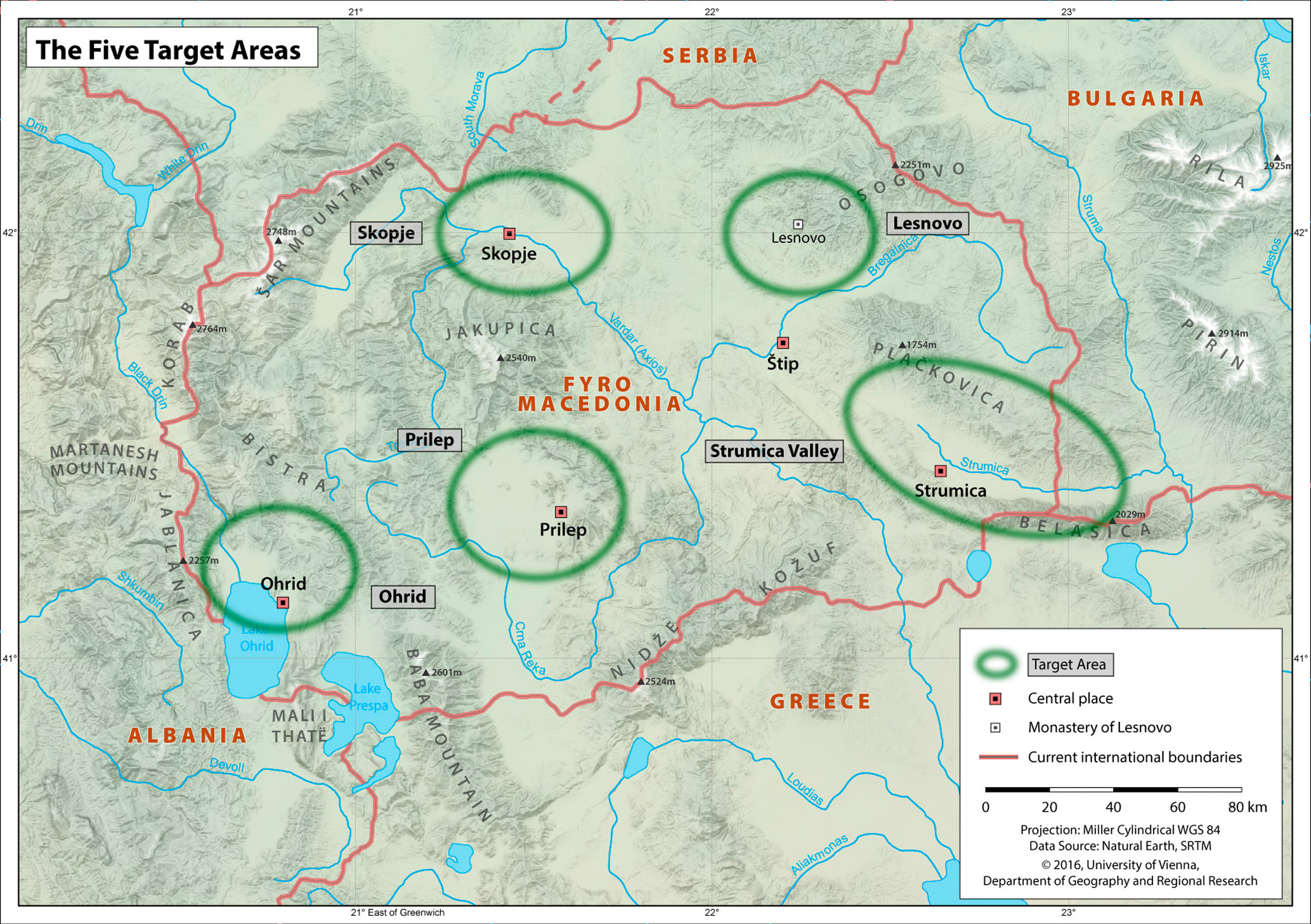
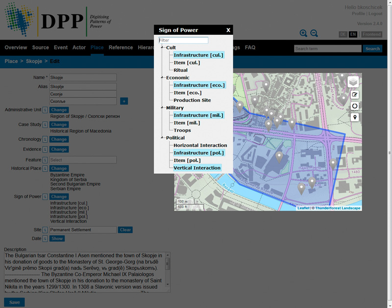
The resulting type tree has already been implemented in the DPP OpenAtlas Database. The “Signs of Power” will exclusively be tagged within the entity Place. Moreover, the DPP OpenAtlas Database enables the user to tag places even with several of these “Signs of Power” in order to represent places of greater or lesser importance (figs. 2a and 2b).
-
- Fig. 2a: Multiple Selection from the “Signs of Power” Tree, Design: Alexander Watzinger.
-
- Fig. 2b: “Signs of Power” added to the Entity of Skopje, Design: Alexander Watzinger.
The crucial question, how “Signs of Power” can be made visible on the basis of our data and then displayed in the prominent frontend of DPP, the DPP Mapviewer, shall be addressed in the following defined small case studies on Byzantine Macedonia. This DPP Mapviewer is developed by our project partner within DPP, the Department of Geography and Regional Research (University of Vienna, Group Leader: Prof. Dr. Karel Kriz), is currently in the development stage of the second prototype and will be the prominent frontend of DPP. This application will serve two equally important functions: one function is to enable the scholars of DPP and “Byzantino-Serbian Border Zones in Transition” to view the spatial data and explore spatial relations between different database entities and, thus, gain insight into the medieval landscape. The second function of the application is to present the respective research and its results to an interested public audience.
In the final application key results of our research will be communicated via “story maps”, i.e. predefined views of the data, which are complemented with a detailed description of the topic shown and information about its significance for historiography. Moreover, a query builder will allow the user to explore the data stored within the DPP OpenAtlas Database and show the results on the map.
Ways to Apply “Signs of Power”
An Example of a Political “Sign of Power”
Тhe expansion of the medieval Serbian kingdom to the South under king Stefan Uroš II Milutin until the death of tsar Stefan Uroš IV Dušan (i.e. from 1282 to 1355) caused significant changes in the border zone of what is today Northern Greece and the (Former Yugoslav) Republic of Macedonia. The Byzantine border-warlords, administrative functionaries and local aristocrats were of course one of the groups, which were the most affected ones by the guerilla warfare and the progressing expansion of the Serbian kingdom. Many names which sound Greek appear in the Slavonic and Greek charters issued by the Serbian kings. In most cases they only record the change of properties in the area. The history of these local families is very often omitted in prosopographical research.
A good and figurative example for this shortcoming is the entry on “Demetrios (?) Misinopolites” in the Prosopographisches Lexikon der Palaiologenzeit (in the following: PLP). He is described as a nobleman from Mosynopolis in Thrace. As a donor of the metochion of St. Demetrius in Varoš, i.e. in the lower town of medieval Prilep, he sponsored the renovation and the painted decoration of the metochion’s church (fig. 3).
-
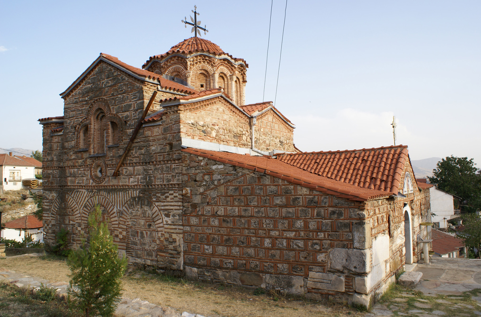
- Fig. 3: The Church of St. Demetrius (Sveti Dimitrija) in Varoš, Prilep, from the North, Photograph: Mihailo St. Popović (2008).
The author of the PLP entry drew this data from the Serbian scholar Vojislav Djurić and, therefore, he didn’t know, if or where the donor-inscription was edited. The inscription reads in its most recent edition as follows:
δέ(ησις) τοῦ δού[λου] τοῦ θ(εο)ῦ Δημητρίου τοῦ Μησηνοπολήτου καὶ κτήτορ(ος) τοῦ ναοῦ.
The church of St. Demetrius lies in the east of the former medieval lower town of Prilep. It formed an integral part of the town’s medieval main square and was erected in several phases from the 12th until the 14th century. The original building was a small one-nave church in the second half of the 12th century. In 1284 the whole church was decorated with new frescoes. A fundamental reconstruction was undertaken in the middle of the 14th century.
The analysis of the three Slavonic charters of the Serbian king Stefan Uroš IV Dušan for the Monastery of the Holy Mother of God of Treskavec to the north of Prilep can shed more light on the family Misinopolites. After the conquest of the town of Prilep and its surrounding area, king Stefan Dušan issued his first charter for the aforesaid monastery in 1334/35. Therein, he donated villages, settlements, abandoned lands, summer and winter pastures, watermills, metochia and churches as well as a fair in the town of Prilep to the monastery. The second charter of king Stefan Dušan for the Monastery of Treskavec is dated to 1343/44. The king confirmed the existing properties and donated further villages, settlements, abandoned lands, summer and winter pastures, watermills, metochia and churches in the region of Prilep to the monastery. Finally, king Stefan Dušan issued his third charter for the monastery in 1344/45.
Božidar Ferjančić argued that the second charter (Treskavec 2) for the Monastery of Treskavec is a forgery, while the first and third (Treskavec 1 and 3) are authentic. Djordje Bubalo advanced the opinion that the second charter (Treskavec 2) is an unofficial document based on the first and the third charter (Treskavec 1 and 3).
From the charters emerges clearly the fact that apart from a man called Misinopolites also his children appear. We don’t know much about the man called Misinopolites. He was definitely a wealthy and respected person in Prilep and its surrounding region. At his disposal was a nearly 9 hectare large estate, which lay – according to the context of the charters – in the vicinity of the estates of the Byzantine emperor and was sold by Misinopolites to the Monastery of Treskavec at an unknown date. Moreover, the king confirmed and donated the metochion (and church) of St. Demetrius, which was given to the Monastery of Treskavec by the children of Misinopolites, with its fields, vineyards and watermills as well as with its fair to the same monastery (Metohь Svetii Dimitrїe u Prilěpě, što priložihu Misinopolitova dětьca, sь nivijemь i sь vinogradi i sь voděnicami i sь Kučьkověne selištemь i sь panagiromь i sь vьseju pravinoju togo). This means that the children of Misinopolites inherited the metochion of St. Demetrius with its possessions and the settlement site or abandoned village (selište) of Kučьkověne from their father and donated it most probably to the Monastery of Treskavec after the Serbian conquest of Prilep.
In the year 1343/44 king Stefan Uroš IV Dušan confirmed the donation of the metochion St. Demetrius in the town of Prilep with the fair, vineyards and the watermill to the Monastery of Treskavec (Vь gradě motohь Svetyi Dimitrie Misinopolitivь panagirь za[dušnica Misinopolitovihь] dětei sь nivijemь, sь vinograd[y, sь voděni]cijemь, sь vsěmi pravinami and Selište Kučkověne sь nivijemь, sь voděnicijemь, sь vinogrady, sь vsěmi pravinami). The second charter points to the fact that the annual fair, which was held in eternal memory of Misinopolites on behalf of his children (panagirь zadušnica Misinopolitovihь dětei) near to the metochion of St. Demetrius in Varoš, bore the name of Misinopolites.
Finally, the king confirmed the donation of the metochion of St. Demetrius with vineyards and a mill to the Monastery of Treskavec in 1344/45 (Metohь Svetyi [Dimitrïe] u Prilěpě s niviemь, sь vinogradi, sь mlini i sь vsěmi pravinami and Selo Kučkovьjane, sь niviemь, sь vinogrady, sь mlini, sь vsomь pravinomь).
These extensive possessions enabled Misinopolites to renovate, decorate and financially secure the church of St. Demetrius. It is uncertain, whether the preserved portrait of the donor in the church itself and the donor inscription in the southern aisle of the western part of the church attest the father Misinopolites or his son, as Boško Babić has proposed. It is not even clear, when the donor composition was designed. Boško Babić pled for the year 1284 as the terminus post quem, because of the second votive supplication inscription in the name of the Byzantine emperor Andronikos II Palaiologos and his wife Eirene of Monferrat in the church of St. Demetrius. Recently, a new chronology has been proposed, which dates the painting decoration before the year 1284 and identifies Andronikos and Eirene as an aristocratic couple.
The aforesaid outline on the family of Misinopolites illustrates, as a small case study within the project “Byzantino-Serbian Border Zones in Transition”, the change of power and ruling elites in the five target areas in Byzantine Macedonia, i.e. the regions of Skopje, Lesnovo, Strumica, Prilep and Ohrid, where we witness in general a flight of Byzantine noblemen and landowners from their landed properties in the wake of the expansion of the Serbian medieval kingdom and a redistribution of abandoned land and of privileges to Serbian noblemen by the Serbian rulers. This vivid example will serve as a basis in order to elaborate in depth studies within the project “Byzantino-Serbian Border Zones in Transition” on border-warlords, administrative functionaries and local aristocrats in the respective border zones.
An Example of an Economic “Sign of Power”
Another example, this time for economic “Signs of Power”, represents the existence and the localisation of vineyards and mills in the respective sources on the five target areas in Byzantine Macedonia. The underlying idea for this very approach is that vineyards and mills represent medieval economic “Signs of Power” regardless of space and place in medieval Europe.
The Byzantinist Kostas Smyrlis elaborates on the significance of vineyards in Byzantine Macedonia as follows: “Vineyards, whose produce of grapes and above all wine was particularly profitable, were to be found almost everywhere. They were usually cultivated in small plots belonging to, or rented by, peasants, though large vineyards, owned by landlords, were also common. […] In certain parts of Macedonia, vineyards covered as much as 16 percent of the cultivated area.”
From my point of view our systemic approach of economic “Signs of Power” has the advantage that it is an approach of localisation, distribution, visualisation and comparison, since we lack quantitative data on the production in the respective vineyards and mills. The respective results can be visualised via the frontend of the project DPP, which is the DPP Mapviewer (fig. 4).
-
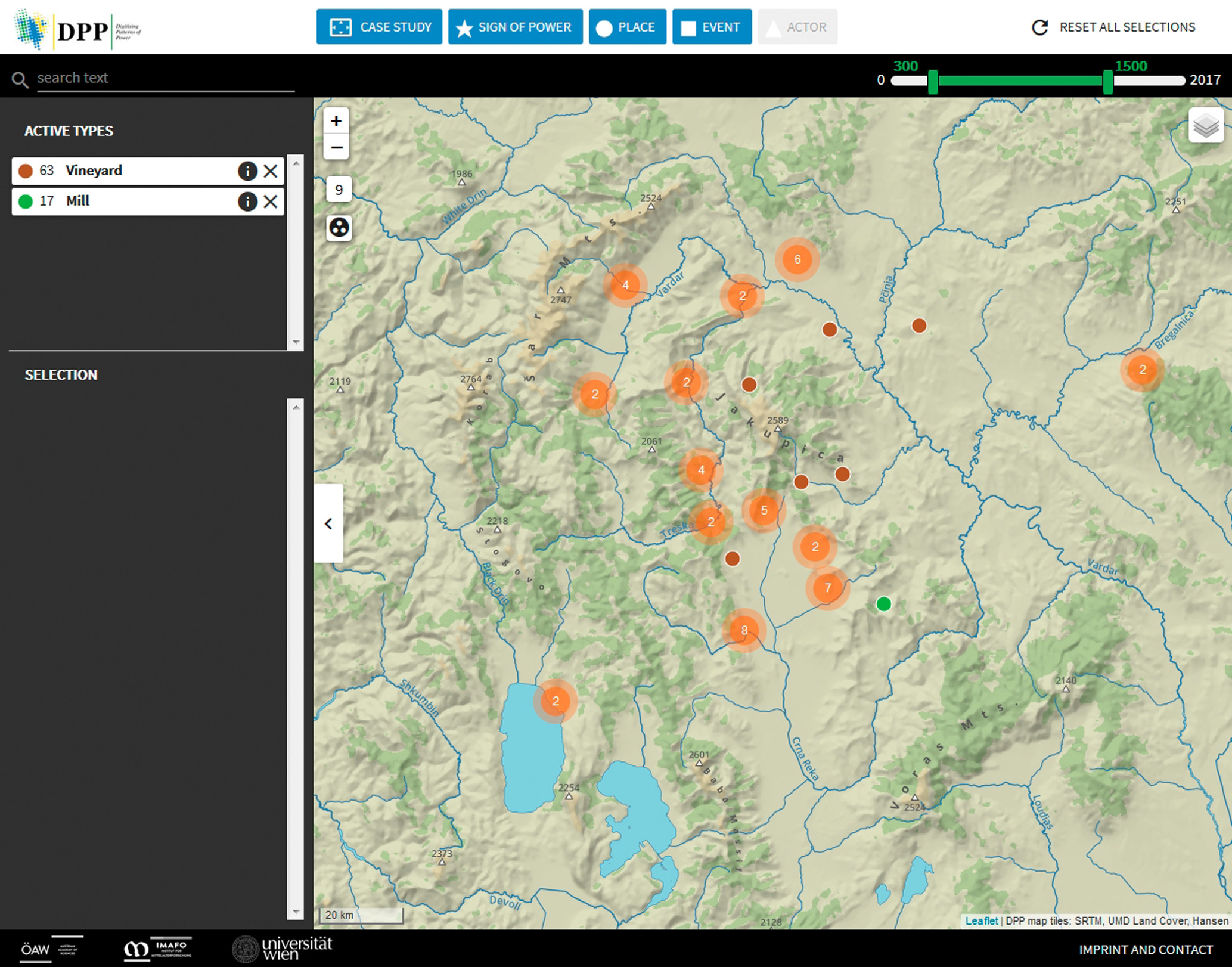
- Fig. 4: The DPP Prototype Mapviewer with the Selection of Vineyards and Mills focused on the Skopje and Prilep Region, Design: Markus Breier.
A Joint Example of a Political and an Economic “Sign of Power”
The three aforesaid charters for the Monastery of Treskavec from 1334 to 1345 mention various roads on the micro level, mainly in the boundary descriptions of those villages, which were donated by the Serbian king Stefan Dušan to the monastery. This fact illustrates the importance of roads for the mental mapping of the inhabitants of a specific area and highlights their function as remarkable and unique lines to draw property boundaries. The three charters mention in total 23 times a drum or a putь, which are the Slavonic terms for “road”. These roads were often named after the village or town, to which or from which they ran, for example the putь Kučkověnьskogo (the road from/to Kučkověne) or the hraštanski putь (the road from/to Hraštani) (fig. 5). Others have names with a special and/or unique topographic characteristic, for example the prisadьsky putь,which ran over the pass of Prisad to the North-East of Prilep.
-
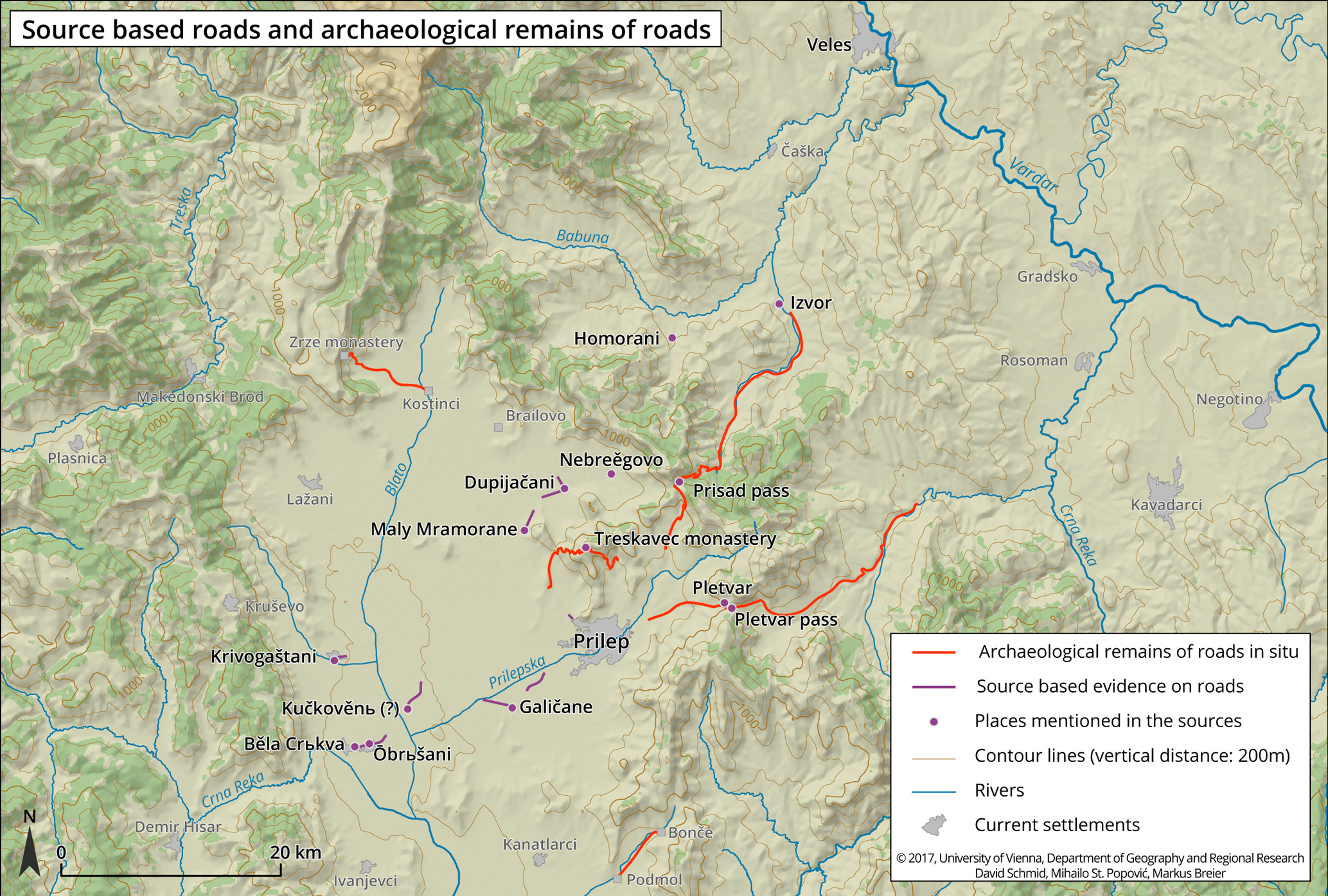
- Fig. 5: Source based Roads and Archaeological Remains of Roads in the Prilep Region, Design: Markus Breier .
Based on the aforesaid three charters we are able to discern four zones of transportation, namely around the villages of Krivogaštane, Ōbrьšani with Běla Crьkva, Galičane to the south of Prilep and a zone between Maly Mramorane and Dupijačani to the north of Prilep.
Most fascinating and puzzling is the fact that the aforesaid roads, which are attested in the charters of the Serbian king Stefan Dušan for the Monastery in Treskavec, cannot be found in situ, i.e. the respective landscape, today. Hereby, our analysis is based on systematic field trips, which were conducted by Mihailo St. Popović and Peter Soustal in September 2008 and in June 2016 for the TIB volume 16 “Macedonia, Northern Part” within the Long Term Project “Tabula Imperii Byzantini (TIB)” of the Austrian Academy of Sciences.
The only exception is the prisadьsky putь, which is named after the pass of Prisad and which connects the valley of the river Vardar (i.e. Veles) as well as of the river Babuna (via the place of Izvor) with the plain of Pelagonia (i.e. Prilep) (fig. 5). This road is not only attested in the medieval charters, but also in travel accounts or reports of the 19th and 20th centuries. Thus, the prisadьsky putь has a continuity at least from the Middle Ages until our time.
The German zoologist Franz John Theodor Doflein (1873-1924) mentions the road over the pass of Pletvar (fig. 5), which we cannot find in the aforesaid medieval charters. It connected the valley of the river Vardar (from Gradsko) with the plain of Pelagonia and must have already existed in the Middle Ages. Boban Petrovski surmises that Timurtaş, the Beylerbey of Rumelia, left the town of Serres in the spring of 1385, marched with his army via Dojran to Demir Kapija and then traversed the pass of Pletvar in order to conquer Prilep and Bitola. After that he led his army on the Via Egnatia to Ohrid, which he also captured.
Moreover, we used the western road in 2008 and the eastern road in 2016 during our field trips to hike to the Monastery of the Holy Mother of God in Treskavec (fig. 5). In both cases we came across substantial remnants of the respective roads (fig. 6), which we are not able to date due to the lack of archaeological excavations and finds.
-
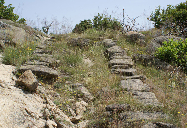
- Fig. 6: Remnants of the Eastern Road to the Monastery of the Holy Mother of God in Treskavec, Photograph: Mihailo St. Popović (2016).
-
- Fig. 7: The Old Road between the Villages of Podmol and Bonče, Photograph: Mihailo St. Popović (2016).
In 2008 we also found remnants of a road, which connected the village of Kostinci to the Monastery of Zrze running in East-West direction (fig. 5), as well as traces of a road between the villages of Brailovo and Desovo, both in the plain of Pelagonia (fig. 5). Again a dating could not be undertaken due to the lack of archaeological evidence in situ. Finally, there is also an old road between the villages of Podmol and Bonče, which we documented in 2016 (fig. 7).
On the one hand remnants of roads on a micro level imply certainly a strong economic aspect. Therefore, we could well tag them as an economic “Sign of Power” within our DPP OpenAtlas Database. On the other hand roads become a political “Sign of Power” on the macro level, if they are used by an emperor or king in the sense of an ambulant kingship. Here, we could resort to the itineraries of king Stefan Dušan in Byzantine Macedonia, which were reconstructed by the Serbian scholar Miodrag A. Purković. Their visualisation (fig. 8) helps us to become aware of the patterns of royal movement in a contested border zone and understand its role in the appropriation of space through imperial power.
-
- Fig. 8: The Itineraries of King Stefan Dušan in Byzantine Macedonia according to Miodrag A. Purković, Design: Bernhard Koschicek (ArcGIS).
This approach leads us directly to the two interrelated research questions within the FWF Austrian Science Fund Project P 30384-G28 “Byzantino-Serbian Border Zones in Transition: Migration and Elite Change in pre-Ottoman Macedonia (1282-1355)”, which are addressed in two distinct work packages: “Rivalling Political Concepts – Byzantium and the Medieval Serbian Oecumene” and “Cross-Border Societies and Elite Change in Byzantine Macedonia”. Special attention is given to the analysis of formulations in Byzantine and Serbian charters with regard to the Serbian expansion in the area of research, the acquisition of new territories and their administrative incorporation on the macro-level and to the localisation of conquered settlements with related settlement typologies as well as on the change of local elites on a micro-level.
Conclusion
With the three aforesaid examples we ventured to illustrate, how “Signs of Power” could be defined based on our specific sources and in depth research and in which way they can be visualised by using tools deriving from Digital Humanities. Our aim in the near future is to elaborate in detail on further examples, to enrich our expertise and to path the way for a “best practice” in this very field, which then could be applied to other European areas of research.
In the field of Digital Humanities there is an ongoing discussion on the definition of what Digital Humanities actually are. It is not surprising that there is not a single definition, but that there are manifold approaches to the topic. Digital Humanities in History and Historical Geography is often understood as digital documentation of sources as well as monuments. This can be the scan of a medieval charter or the virtual reconstruction of a monument and many more. Closely connected to this aspect is also the presentation and visualisation of sources and research results.
The projects DPP and “Byzantino-Serbian Border Zones in Transition” aim at fulfilling these tasks regarding Digital Humanities. Apart from the development of the OpenAtlas Software we focus on digital visualisation and publication with a special focus on geocommunication of our data and results to academia and the interested public.