A step towards understanding neighbourhood formation
![]()

Abstract
Neighbourhoods constitute a basic element of social and spatial town structure. Yet, only few studies in historical urban research attempt to define and contextualize them. In this paper, we describe the formation, existence and evolution of neighbourhoods in medieval chartered towns in Central Europe using archaeological, architectural and written sources. Specifically, we: 1) traced material elements of the built environment enabling face-to-face communication, 2) identified spaces fostering community building and 3) considered how to find neighbourhoods within the city matrix. We show that neighbourly relations mainly concerned infrastructure maintenance and that spatial development diminished inter-plot connectivity inducing shift of social interactions to streets. Thus, material markers of neighbourhoods can provide a distinct perspective for tracing social urban interactions.
Abstract (German)
Nachbarschaften stellen ein grundsätzliches Element sozialer und räumlicher Struktur von Städten dar. Dennoch gibt es in der historischen Städteforschung nur wenige Versuche, die diese definieren und in Kontext stellen. In diesem Artikel beschreiben wir die Entstehung, den Fortbestand und die Entwicklung von Nachbarschaften in mittelalterlichen, zentral-europäischen Lokationsstädten mithilfe archäologischer, architektonischer und schriftlicher Quellen. Im Besonderen haben wir: 1) materielle Elemente der gebauten Umwelt nachverfolgt, die face-to-face Kommunikation ermöglichen, 2) Räume, die Gemeinschaftsbildung ermöglichen identifiziert und 3) untersucht, wie Nachbarschaften in der Stadt-Matrix gefunden werden können. Wir zeigen, dass nachbarschaftliche Verhältnisse hauptsächlich für die Erhaltung der Infrastruktur zuständig waren und dass räumliche Entwicklung die Vernetzung zwischen Nachbarschaftsparzellen senkt, was soziale Interaktionen auf die Straßen verlagert. Folglich können materielle Zeichen von Nachbarschaften eine eigenständige Perspektive, soziale städtische Interaktionen zu verfolgen, bieten.
Table of contents
Introduction
The term ‘neighbourhood’ seems to have a very conspicuous meaning, simply referring to a well-known area where one lives, although at a closer look such an understanding of ‘neighbourhood’ is very subjective and vague. It can be read differently according to context or even the language one speaks. For example, in modern urban studies, neighbourhood is considered as one of the smallest (basic) units of urban social organization. It can be defined based on walking distance (up to 10 minutes), physical enclosure, administrative division, identity based on proximity to a topographical feature, and social characteristics (ethnicity, occupation, income etc.). The neighbourhood is almost always associated with a community. One without a community is considered deficient, dysfunctional and doomed. Since neighbourhoods are important features of urban life they are also in the area of interest of archaeology, history and other social sciences. In the context of historical studies, one of the key issues is to identify a neighbourhood in historical sources. M.E. Smith in a review on tracing the neighbourhood through archaeological methods, defines it as (drawing on modern sociological theories) “a residential zone that has considerable face-to-face interaction and is distinctive on the basis of physical and/or social characteristics”. In an anthropological archaeology perspective neighbourhoods are seen as “residential, social landscapes that serve to integrate multiple households without homogenizing residents”. In European research on medieval and early modern towns this clear, ‘archaeological’ definition has not been employed by historical studies. Instead, a multitude of approaches exist, depending on the subject under study. Neighbourhoods can be described as local communities connected by attending the same parish church or by a membership of a secular or sacral association (for instance in medieval and renaissance Italian cities. Sometimes the term ‘neighbourhood’ is not explicitly defined and used interchangeably with the term ‘district’ or identified with a ‘quartier’.
The problem of defining the ‘neighbourhood’ is especially interesting in medieval chartered towns in Central Europe (German: Lokationstadt). On the lands east of the river Elbe new towns emerged in two ways: either old urban centres (e.g. Krakow, Wrocław) were reorganized, or newly rising towns were founded (e.g. Culm, Elbląg), and both types were organized based on German law (Law of Magdeburg, Law of Lübeck, Law of Culm). As a consequence, their legal and spatial organization was based on the principles of this law, and as such created the framework for neighbourhood emergence within these towns. The legal organization indicated that a town, which was granted legal autonomy in relation to territorial authorities by virtue of locatio, developed its own government, which included the voyt (Latin: advocatus): an alderman with officium scabinatus (echevins) and the Council with a burgomaster exercising power (including judicial power) in the town. The spatial organization was reflected in a well-measured plan of the town with a separate area for the market place surrounded by a regular street network and city-blocks. The latter included the settlement parcels of land with specific modular measurements. These parcels of land were held by burghers and were subject to perpetual ground rents, but their holders had complete property rights (i.e. the right of purchase and sale, the right of inheritance, etc.). The inhabitants of these plots were often changing due to an inflow of newcomers, as well as mobility inside the city walls. Under these circumstances, various social communities were shaped: families (including domestic servants), neighbourhoods, and professional, or sometimes even ethnic, communities. The neighbourhood communities represented, apart from those of the family, the most important types of social ties in pre-industrial towns, and neighbour space was crucial for communication in the medieval town. Thus, the clearly defined foundation law had its manifestation not only in social life, but also in the physical form of these towns, which opens up the possibility of investigating the neighbourhood through materiality.
In this paper we would like to contribute to an understanding of the formation and existence of neighbourhoods in central European medieval chartered towns through studying their material form. Modern studies of urban life indicate that the material space is vital for creating and maintaining social relations. We have assumed that the formation and existence of neighbourhoods is based on face-to-face relations between inhabitants (neighbours) in a given space. Our specific aim was to: 1) trace elements of the built environment that allow or enable communication; 2) identify spaces which potentially fostered social cohesion and community building; and 3) consider where one should look for a neighbourhood in a chartered town. To achieve these goals, we used examples from large chartered towns from the area of today’s Poland, mainly Krakow and Wrocław, dated from the 13th to 16th century (a period of development of chartered towns). In this short paper we could only note the most important issues, that is why we chose places with a good state of preservation both in terms of historical and archaeological data.
Methods and sources
To better understand neighbourly interactions, we employed a three-element methodological approach. (1) We described and analysed elements of the urban space based on archaeological and architectural sources by investigating accessibility (where one could walk and meet, i.e. streets, markets) and identifying the elements that could lead to conflict or cooperation (wells, latrines, gutters). (2) In the next step we traced these material elements in urban written records to find out how people perceived and used them. Such an approach, inherent to historical archaeology, can give a fresh insight into the past through correspondence, contradiction, or mutual complementation of text and artefact. (3) We then looked at the development of the built environment – as reflected by archaeological and architectural phases and complemented by written sources – within a wide chronological scope to capture possible changes in neighbourly relations.
Archaeological and architectural sources included features like: masonry and wooden constructions of houses, sanitary and production infrastructure, border markers (fences, walls) as well as finds like traces of daily activities (production, waste disposal, communication, etc.). Archaeological and architectural remains analysis can determine not only functions and forms but also the chronology of changes. In the case of neighbourly relations, these types of material sources can be particularly useful for identifying the usage of space: where people were walking and meeting and what kind of common facilities were they using. In the current paper, the information on archaeological and architectural features were derived mainly from published archaeological reports and derived publications.
The main written sources concerning neighbourly relations considered by us included all surviving types of court books and documents of towns of varying sizes in the Polish lands from the 14th through the second half of the 16th century. Among them were town councillors’ books, books of the tribunal of the advocatus, and echevin books. In the case of Krakow, archival research also embraced separate books of testaments and town account books, as well as books of the municipal building inspectors (Latin: quartalienses; Polish: wiertelnicy). The vast majority of town books and documents were manuscripts, usually in Latin, but some were in German. In the court books (the equivalent of the notary books of southern Europe) all real estate transactions were registered, and a detailed analysis of all these allowed us to recreate ownerships in a town on each plot and street. Such socio-topographical investigations allowed us to understand relations between plot owners on different levels: within city-blocks, on streets and in quarters.
Markers of neighbourly relations
The structure of the built environment in chartered towns: a basis for developing neighbourly relations
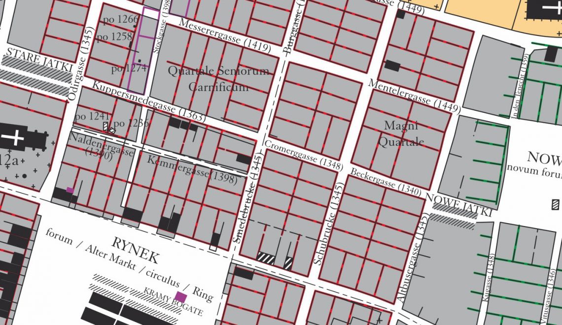
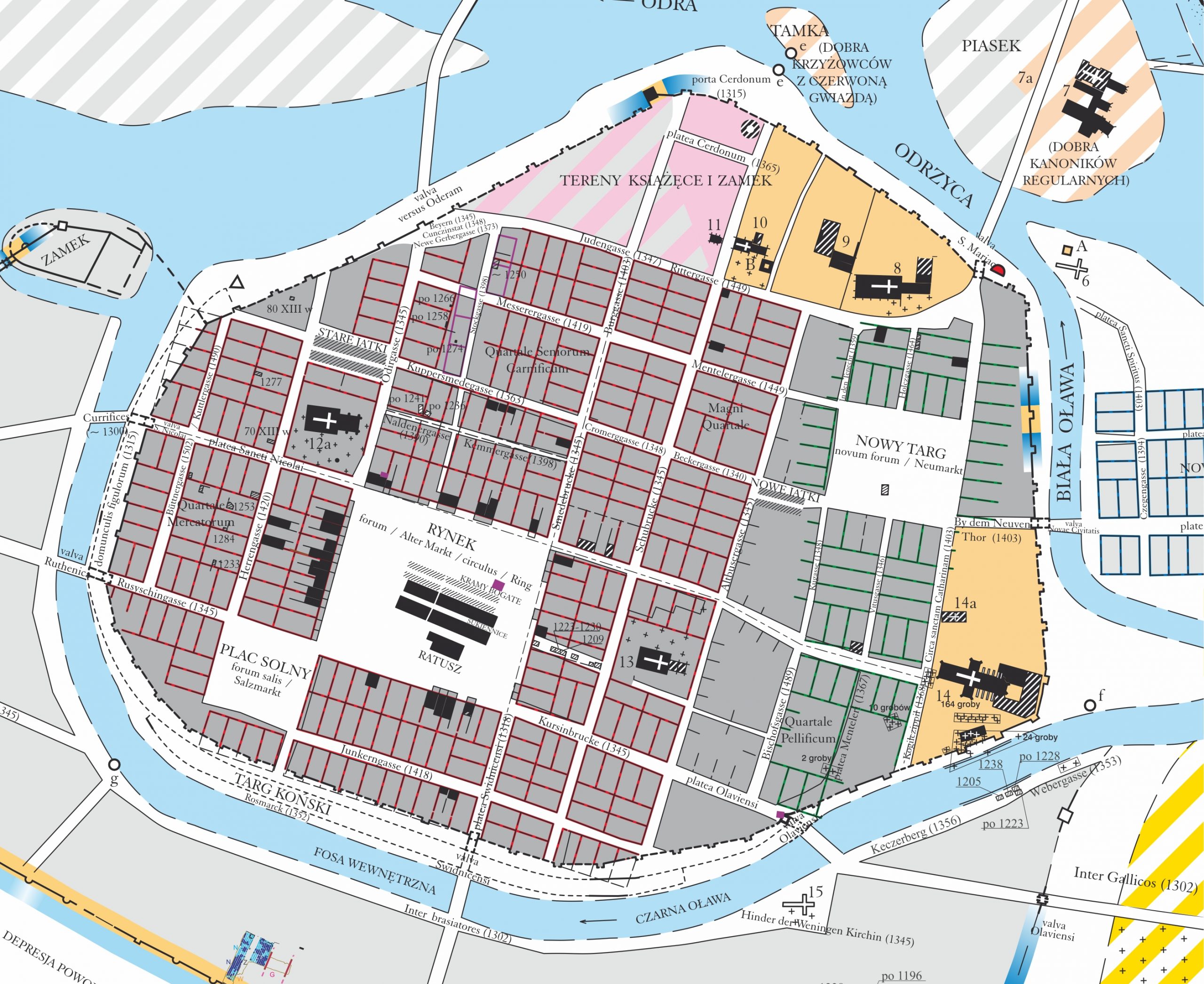
The form and localization of elements of the built environment connected with neighbourly relations depended on the spatial organization of the urban space. A characteristic feature of the chartered towns was a regular urban layout in the form of a grid plan. The layout consisted of: 1) a regular market square (rarely more than one) or a market-street; 2) city-blocks with rectangular urban plots (some blocks were designated for a church); 3) parallel streets that separated city-blocks; and 4) a delimitation of the main urban area (a ditch, fence, city-wall). The regular grid had an ideological and aesthetic significance, but primarily created a modular system of space delimitation. It allowed for the easy addition of new streets and blocks to an old structure according to similar regulations. The process of creating a new urban layout started in the centre and continued outwards to the peripheries. The first delimited part of a new town was the market square with its surrounding city-blocks. Additional city-blocks were added behind the first ones according to need. The process continued until the blocks fully covered the space inside the town boundaries, for example in medieval Wrocław; in some cases, part of an intramural space was left open for a longer period. Each city-block in a grid contained rectangular plots, with plots oriented with the shorter side towards a street. The number of plots and their exact orientation in each city-block was dependant on the design of the urban layout and the course of the major communication routes in a town. In smaller towns (initially) blocks contained only one row of plots, but in larger urban centres it was usually two rows (Fig. 1). The size of the plot and the city-block was based on the modular element’s dimensions within the grid, but from the beginning it was subjected to divisions and transformations. Each town had main roads leading from gates to the market square, secondary streets with lower communication importance, and side streets connecting to the main ones. Here, we focused on showing that neighbourly relations depended on the type of material structure present, and will describe relations within three elements of the urban layout: plot, block, and street.
-
- Fig. 1. Original division of city-blocks in Wrocław west from Market Square. Arrows indicate directions of communication. Base map: The Historical Atlas of Polish Towns, Vol. IV Śląsk, Issue 13 Wrocław, Wrocław 2017, Map 5: Wrocław around 1300, By: M. Chorowska, Cz. Lasota, T. Kastek, J. Połamarczuk.
Basic unit: an urban plot (borders and infrastructure)
A plot (Latin Area, curia; German Hof) constituted the basic spatial unit of medieval chartered towns. The plot functioned as a living and working space for the owner and his family. Basic features inside the boundaries of a plot included: a house, service buildings (sheds, warehouses, workshops, fireplaces, barns, etc.), sanitary devices (dug wells, cesspits, gutters), communication routes, and sometimes gardens. Within some plots, especially in larger towns like Gdańsk, Wrocław, or Krakow, there existed ‘connections’, which were conduits branching off from the town’s water supply system to reach these plots.
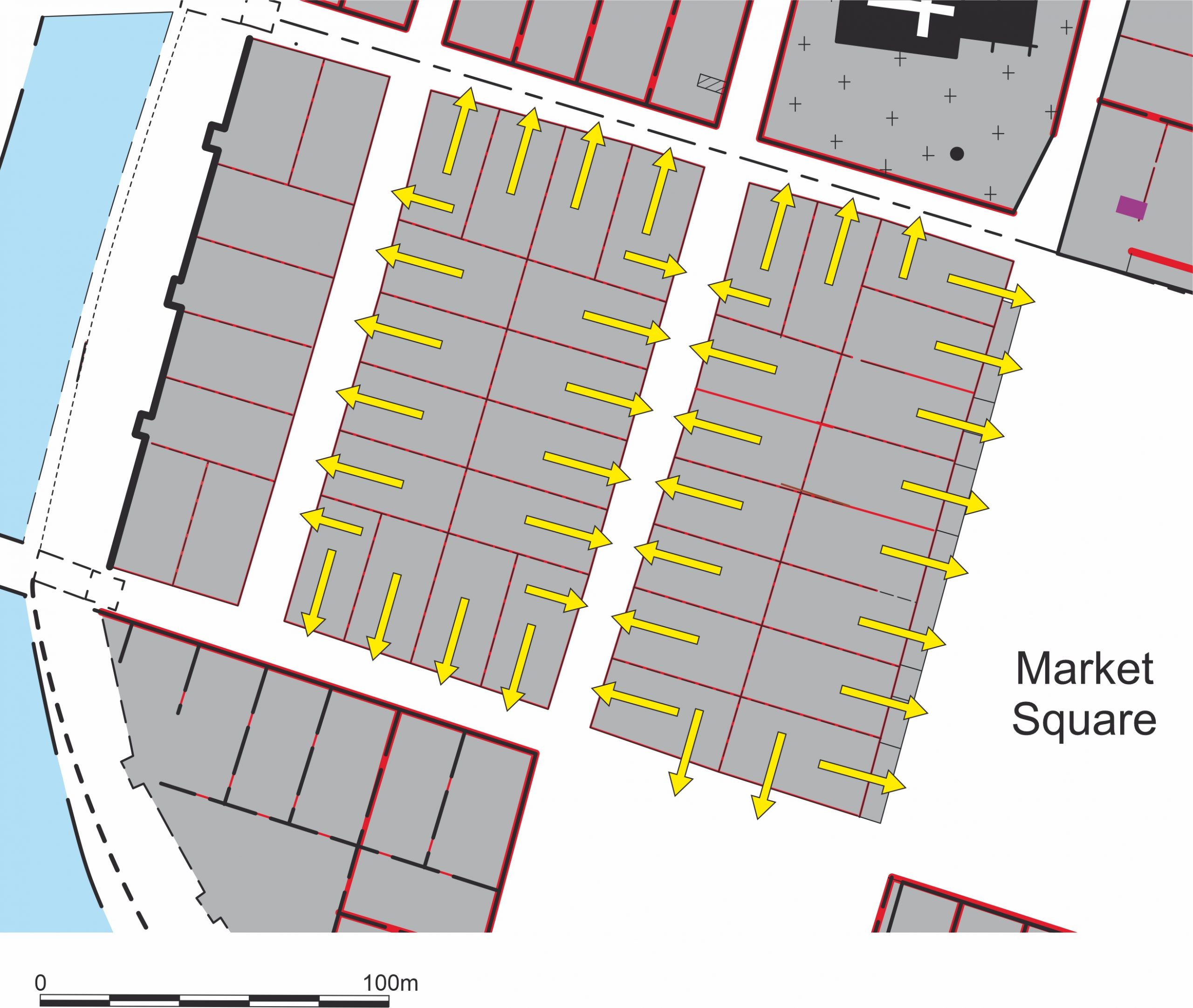
The first element that established relations among neighbours was a boundary. Archaeological excavations indicate their presence from the very beginning of a town’s existence. Boundaries could be marked by constructions and buildings of varying complexity. For example, a fence built from posts and planks was discovered in Elbląg, on the sites on the streets Mostowa 15 and Ducha Świętego 22. The tree used for its construction was cut down in 1237, the assumed year of the town’s foundation. Several phases of wooden constructions built along the fence followed its course, suggesting that the border was long-lasting. In the town of Puck, several wooden fences found in the backyards of the market square plots were rebuilt in the same place in consecutive phases, while others were moved in a process of extending the plot’s area (Fig. 2). Many postholes creating the oldest known borders were registered during excavations in Wrocław in a city-block between św. Mikołaja-Kiełbaśnicza-Ruska-Rzeźnicza streets. Within this block a small wooden building was localized precisely parallel to one of its plot’s borders functioning as a fence. Another way to demark a boundary was a ditch. Such feature, replacing an older fence, was found between the plots on Mikołajska 25 and 26 in Wrocław.
-
- Fig. 2. Puck: (1) Border fence at 10 Lutego 4 street; (2) border fence at Plac Wolności 17 plot.; (3) Reconstruction of primary plot divisions on background of today’s plan of a city=block on south-west side of a town square. A – modern buildings, B – boundaries of buildings and urban plots, C – numbers of excavated plots, D – research excavations, E – uncovered and reconstructed fences and drainage ditches located at boundaries of old burgher plots. – Starski, Michał: Zagospodarowanie parceli mieszczańskich w późnośredniowiecznym Pucku. Dom i jego zaplecze, In: Puck. Kultura materialna małego miasta w późnym średniowieczu, Warszawa 2017, ryc. XV.3. p. 392, ryc. XV.4. p. 393.
It could be assumed that the light construction of a fence (low and wooden) enabled contacts, but in the case of masonry walls the personal contact between neighbours would be restricted. Nevertheless, the urban authorities registered many examples of conflicts or arrangements between neighbours over more solid borders, especially concerning border walls used as part of front house construction (so called fire walls, built to prevent the spreading of a fire). M. Goliński found several examples of such records in the medieval town of Świdnica. Since the neighbour wall was part of the construction of houses on both its sides, it was typically expected that a neighbour who erected such a wall was paid by the other. This caused conflicts, especially when the neighbour was not willing to pay. In such a situation he was forced to pay by the town authorities, and thus the conflict was registered in the official town documents. Such arrangements also concerned the walls in the rear parts of plots. An interesting example, showing the complicated situation involving the space at the rear of a plot, comes from Krakow in 1573. The border wall at the end of some plots was inspected by the municipal building inspectors; it was standing between the properties belonging to a Jan Białogardzki, a cooper (doleator), and Stanisław Lithwinka, a cauldron maker (caldeator). On the cauldron maker’s side some bricks had already eroded, and a clay chimney, lower than the wall, and a cauldron for laundry washing, were all situated just next to the wall. This chimney was considered a threat to a wooden roof installed on the wall by the cooper, and thus a neighbourly conflict emerged requiring intervention by the municipal officials.
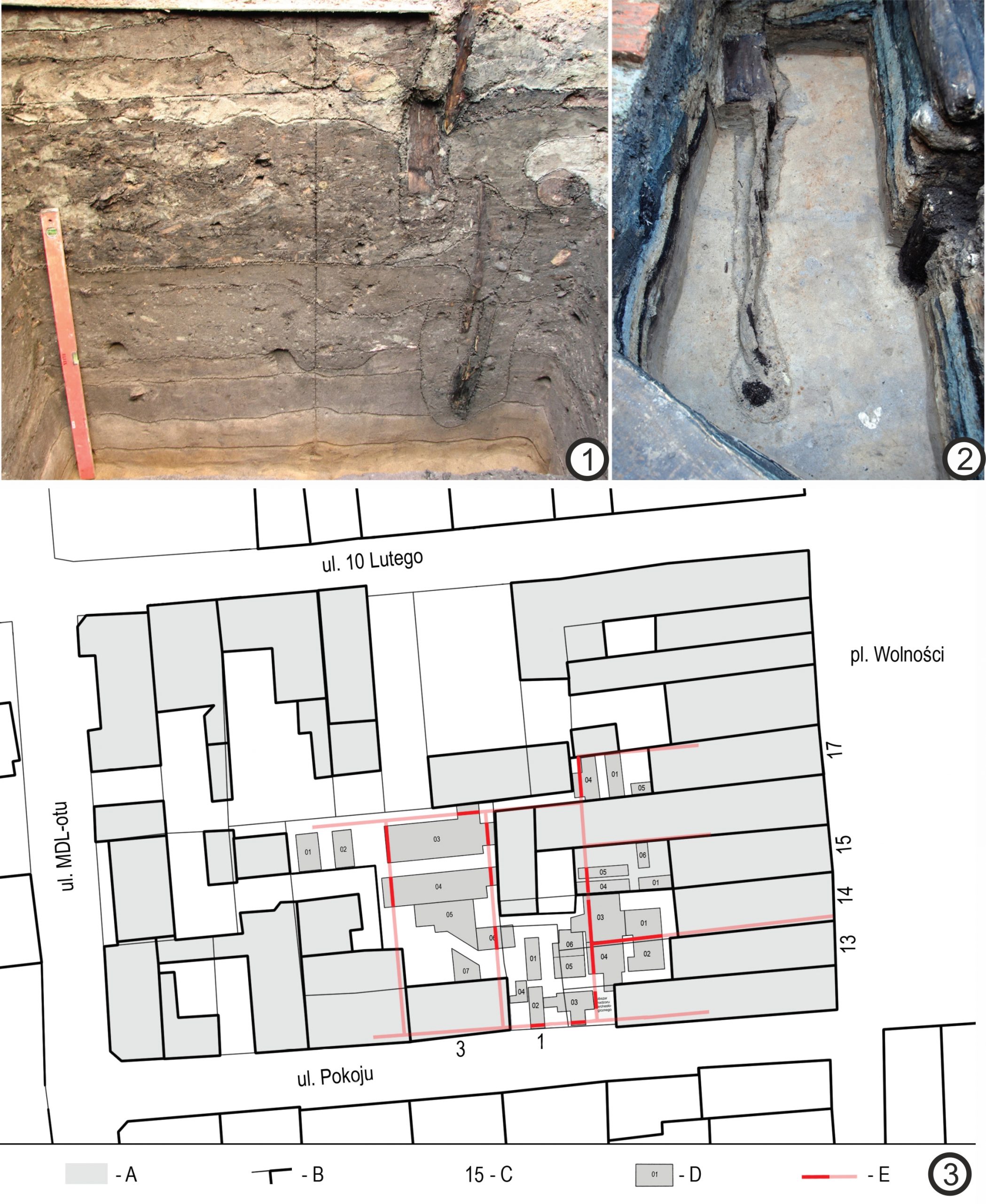
Some elements of plot infrastructure behind the house could also foster neighbourly relations by forcing cooperation. The rear part of a plot developed in accordance with economic needs and the financial capabilities of the owners. Archaeological studies on medieval plots in Wrocław has led to a general conclusion that the town’s plots had three to five functional zones (Fig. 3). A habitational building with a working space was situated in the front part. Behind the house, service buildings were found, such as warehouses, fireplaces, and workshops, followed by the next zone with rear buildings used for habitation or some craft activities (malthouses, workshops, bakeries). Further, there was a space designated as a sanitation zone with wells and cess-pits. In the last zone a garden could be located, however this element was not typical and its presence depended on the plot’s localization within the town and the size of the town. An analysis of peripheral parts of Wrocław showed the existence of three plot zones: the front one with a house, then a nearby yard behind this (with cess-pits, dug wells, workshops, and warehouses), and a rear part with constructions connected to storage and craft production accommodating the needs of the owner. Similar spatial arrangements were traced on medieval plots in Głogów. The plot infrastructure, organised in the abovementioned zones, delivered many elements for developing direct neighbourly relations, and in particular these were water sources and cesspits.
-
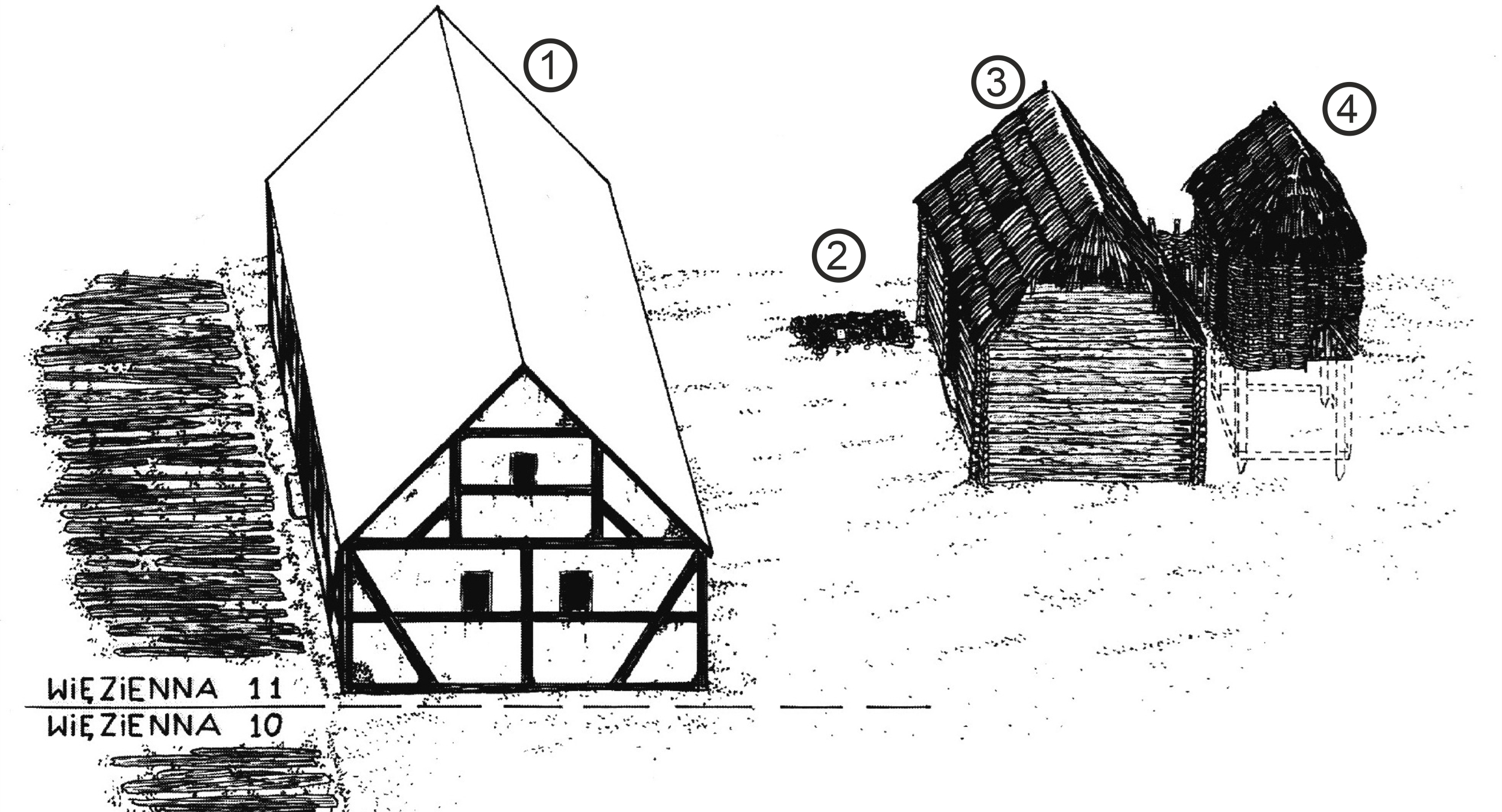
- Fig. 3. Example of spatial organization of a plot. Więzienna 11 Street in Wrocław in the last quarter of the 13th century. (1) front house; (2) hearth; (3) wooden building; (3) cesspit. Graphic: Buśko, Cezary: Rozplanowanie parceli i struktura zawodowa jej mieszkańców, In: Buśko, Cezary/ Piekalski, Jerzy (eds.): Ze studiów nad życiem codziennym w średniowiecznym mieście. Parcele przy ulicy Więziennej 10-11 we Wrocławiu. Wratislavia Antiqua 1, Wrocław 1999, ryc. 4, p. 207.
Neighbour-shared facilities, both providing water for broadly conceived consumption (also for production) and also for discharging wastewaters and/or rainwater, were the most important devices within a plot’s space. The first type of such a facility mainly comprises of dug wells. Archaeological sources indicate that they were often localized in the central or rear part of the plot. Such localization, within a fenced plot, implied that the well served just one property. However, written records indicate that neighbours could have shares in wells localized on an adjacent plot. For example, in 1343 in Krakow, a widow named Alusza sold a house and a plot with a right to use a well on the plot belonging to a neighbour. Access to a water source was particularly important among those who needed water for production purposes due to naturally increased demand. For example, arrangements among brewers in Świdnica specified the amount of money spent by each shareholder for maintaining the well and for access to the infrastructure. Descriptions of these include: “free gate to it [a well]”, “gate and free access [to the well] during day and night”, or “while brewing, the gate (…) should be opened to carry water through the yard”. Sometimes wells were localized on a border between neighbours. In such cases, the arrangements, similarly to the Świdnica case, regulated renovations and access. Thus, in the period under research, dug wells were one of the most important urban elements, not only in organizing the space and society of the town, but also integrating them, mainly in the scope of neighbourhood communities. Defining the level of the neighbours’ shares in the possession of the well was connected both with the possibility of drawing water from it and the taking care of it.
The second type of water facility shared by neighbours comprised common wastewater canals along the border or even through rear parts of the plot. Many archaeologically excavated gutters have been found within plots. For example, border-ditches are known from archaeological excavations in Wrocław, on Św. Mikołaja Street 77–78, where a ditch running along the border was timbered and covered with wooden planks. Another example, representing a simple ditch without stabilizing constructions, was unearthed on Św. Mikołaja 25. Infrastructure on plot borders required maintenance from both neighbours, opening the field for interactions. In late medieval Krakow it was typical to dispose of waste water through a neighbour’s plot. Even though this appears like lawlessness that could easily spark conflict, such solutions were actually part of the water disposal system, something carefully controlled by the town authorities. Still, conflicts between neighbours were inevitable. For example, in 1533, a Seweryn Boner, an important official of the king, sued his neighbour Tomasz Scholc because the latter was disposing of liquid waste from his property into the Boner’s channel (“quod e braseatorio suo meatibus subterraneis aquas immundas sordesque immitteret in canale uicinum domini Castellani quod uulgato nomine flutrinna vocatur” [[…] that sewage and wastewater [dirty water] from [his] malthouse drove through the underground drains into the neighbouring canal of the castellan, which is commonly called flutrinna (sewer)]), which he was not authorized to do.
Another feature that could trigger interpersonal contacts were cesspits, that is places of waste disposal (especially faeces). Such devices are well known from archaeological sources in historical urban areas. Their form varied from small pits filled with waste, to wooden shafts of various constructions (without a bottom), all the way to large masonry constructions that could hold many cubic metres of contents. Usually they were localized on the rear part of the plot creating a ‘sanitation zone’ (see above). Each cesspit could be regularly emptied and thus function for a long time, but often they were buried after they were full, and a new one was built close by. The main problem for neighbourly relations centred on the nature of the cesspits’ contents: faeces and domestic waste. The lack of a bottom resulted in the liquid waste leaking into ground water causing its contamination. The same ground water had to then be used as a freshwater source by the nearby dug wells. Apart from this hazardous situation, it is not hard to imagine that the smell from badly protected cesspits readily resulted in conflicts. Nevertheless, in certain situations cesspits also provided a reason for cooperation. For instance, in Gdańsk a large cesspit (40 m³) was built in the 16th century within a plot on Długi Targ. Later the plot was divided into two parts (Długi Targ 21 and 22). The cesspit was localized exactly on the new borderline, so it had to be divided in the middle by a provisional wooden construction. This construction allowed the device to be used by both neighbours without causing disputes on the degree of individual usage, as this was clearly demarcated.
Much more information about neighbourly relations over cesspits can be found in the written records. Due to their localization in the rear part of a plot, close to land borders, neighbours frequently filed complaints. In Krakow most of the complaints filed to the municipal building inspectors concerned the poor state of latrines. Sources mention cesspits with a cover, which can be identified with the above-mentioned large constructions. Additionally, there is information about smaller devices called “necessary places”, such as privies or latrines. They probably had a form of small wooden shed/hut localized close to a house. Relations over latrines were generally conflicts. One such situation was recorded in Krakow in 1470, when the Długosz brothers (the author of one of the most important Polish chronicles and his younger brother) were accused by their neighbour of building a latrine just at the border wall. Exactly on the other side, by the wall, was their neighbour’s well. The problem of the closeness of the latrine was noticed very early. A rule that can be interpreted as an order to keep a latrine at least 3 feet away from a border fence, is known from the Sachsenspiegel (Bakovene, genge, under swine koben sollen dri vuze von deme zunesten [Ovens, cesspits and pigsties have to be built three feet away from the fence]), as well as from later sources, e.g. from the towns of Elbląg and Wrocław. Sources also mention shared latrines. In a document from Krakow, one neighbour was so tired of another not taking care of their common latrine that he built one for himself on his own property.
A cluster of plots: a city block
We have already looked at relations within single units of urban spatial organization (plots). To get a broader perspective and understand neighbourly relations on a larger scale, we need to move our focus to the whole city-block. Accessibility appears to be particularly important here, that is communication among plots within a block and with the area around it.
The starting point for the further development of a city-block was the regular layout established during the foundation or reorganization of the town. In Krakow, each block contained eight to 16 plots oriented with the shorter side towards two parallel streets, or towards the market square and the streets perpendicular to the market square (Fig. 4). Access to plots was ensured from the main street, and to corner plots additionally from the side street (see Fig. 1). The situation was similar in Wrocław, where blocks had several different sizes and layouts (Fig. 5). This arrangement was rather typical; it was also found in Legnica and in many other towns in central Europe. Unfortunately, fully studied city blocks are rare, however some precious information and an interesting example is available from a well-studied city-block in Wrocław, on the Św. Mikołaja-Kiełbaśnicza-Ruska-Rzeźnicza streets. The block was delimited in the second quarter of the 13th century, shortly after the reorganization of Wrocław according to the German law on civic rights. Metrological analysis of the block indicated that it contained 16 full-sized plots (Latin curiae): four on the north and four on its south side, oriented towards the main streets, and eight in the middle, oriented towards the side streets (Fig. 6).
-

- Fig. 4. Urban layout of Kraków. Reconstruction of a grid from 1257 by B. Krasnowolski superimposed on the 19th century cadastral plan. Map: Krasnowolski, Bogusław: Lokacyjne układy urbanistyczne na obszarze Ziemi Krakowskiej w XIII i XIV wieku. Część I. Miasta Ziemi Krakowskiej – chronologia procesów osadniczych i typologia układów urbanistycznych, Kraków 2004, Il. 3.
-
- Fig. 5. Urban layout of Wrocław around 1300. Reconstruction of original parcellation. Map: The Historical Atlas of Polish Towns, Vol. IV Śląsk, Issue 13 Wrocław, Wrocław 2017, Map 5: Wrocław around 1300, By: M. Chorowska, Cz. Lasota, T. Kastek, J. Połamarczuk.
-
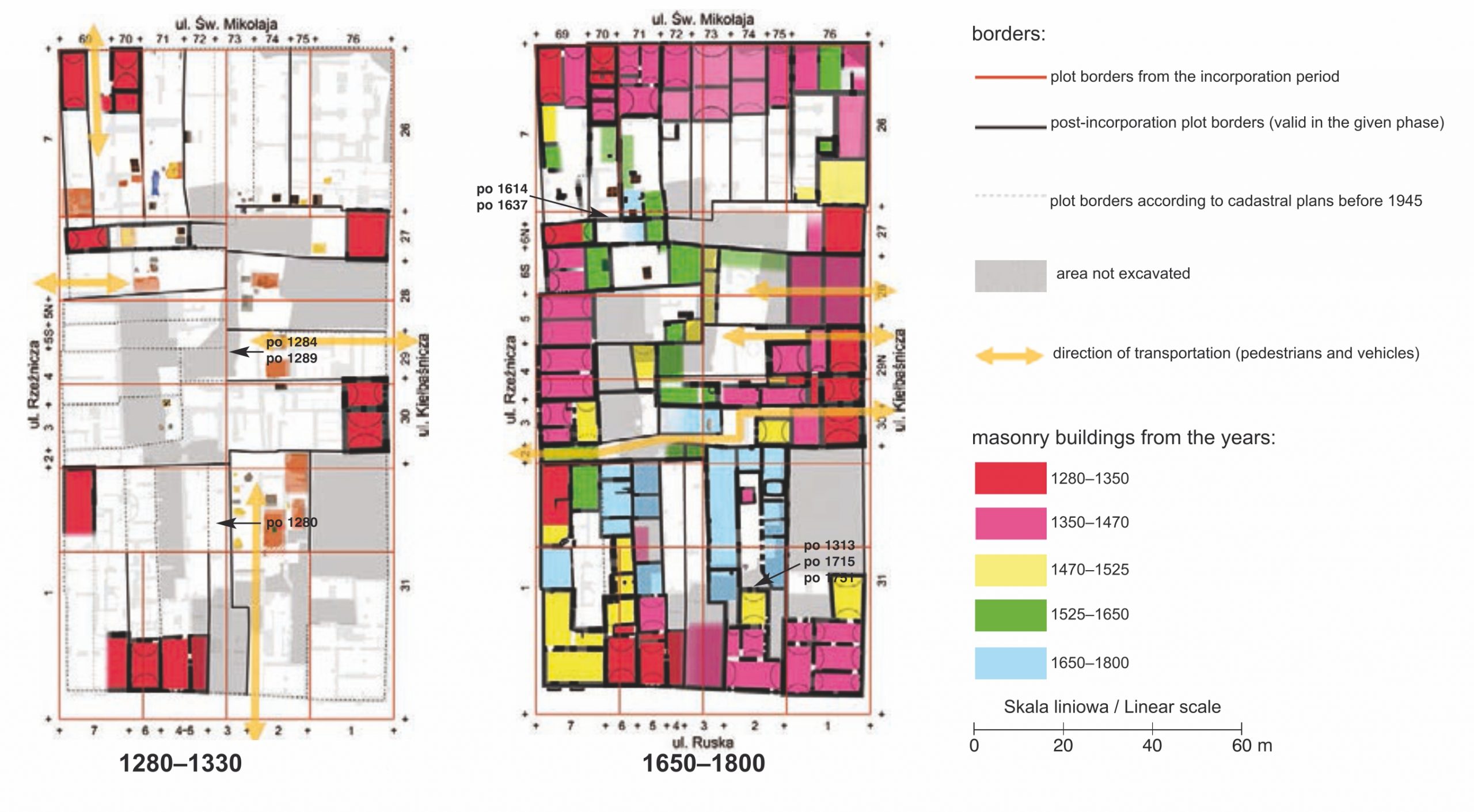
- Fig. 6. Two chronological phases of changes of plot division and development in a city-block between Św. Mikołaja-Kiełbaśnicza-Ruska-Rzeźnicza Streets in Wrocław, reconstructed by M. Chorowska and M. Krzywka. Map: The Historical Atlas of Polish Towns, Vol. IV Śląsk, Issue 13 Wrocław, Wrocław 2017, Map 7: Study of changes in parcellation and development of plots, By: M. Chorowska, M. Krzywka.
Intensive changes in ownership resulted in the connection or division of plots. At first, borders were marked with fences made of perishable materials (timber, wattle and daub), and these borderlines were respected by the oldest constructions at the rear parts of the plots. The internal organization of the plots was rather typical: a wooden front house with an entrance from the yard and service buildings; with production and sanitary infrastructure in the middle or at the rear. The front houses did not occupy the entire width of a plot, allowing for communication with a yard. Important changes happened in the 14th century, when first the front buildings began to be built of bricks. During the 14th and 15th centuries borders between plots were stabilized by permanent walls. Front buildings were extended and occupied the whole width of plots. Easy communication to the yard was now limited to carts, and was probably possible only through the front house. One plot was exceptional because it had access to the yard not through the front house but from the parallel street. As mentioned before, sanitary infrastructure was localized in the rear part of the plot, but on some plots latrines were in the middle, and behind them empty areas were left in the rear. Masonry buildings at the rear of plots started to be raised in the 16th century, and their presence completely blocked connections with neighbouring plots. No internal pathways connecting the plots inside the block were recorded. The abovementioned case provides an excellent opportunity to trace the evolution of within-block communication. Initially, communication was continuous from the streets to the rear part of plots. If we assume that plots were not densely built-up it was possible to easily move from one side of the block to another. The development of the front houses sealed access to the backyard, and developing infrastructure gradually limited access to the adjacent plots.
This pattern was observed in other places as well. In Krakow in the 13th and 14th century, plots by the market square had wide access (for carts) to their rear parts next to the front houses. In the late 14th and 15th century the street front was fully built-up, and all access roads became closed. However, people were often able to find solutions allowing them to circumvent such blockages. In one of the cases, access to the rear part of the house led through the plot in the area behind the market-plots; it was later changed into a regular access road with a common gutter. Another example from Wrocław shows that owners of plots on the north side of the market square took into possession plots behind their properties. This way they gained the connection with the street behind the block as cart access was blocked from the front side by houses. In some cases, access to backyards was provided by narrow streets between houses. Such a pathway dated to the 14th century was found in Krakow on Gołębia street between the remains of two medieval buildings under today’s university.
To conclude, the abovementioned examples suggest that plots were losing their connectivity over the passage of time. Does this mean that communication among neighbours was also compromised over time? It is possible that ways/modes of communication changed but did not diminish, that is transitioned from within the block to the outside: i.e. to the streets. Most probably, development was prioritised over communication, so the loss in neighbourly relations was not considered detrimental. It might also be the case that close coexistence was no longer needed. In any case, written sources, as already mentioned, clearly show that intensive contacts between neighbours persisted despite diminished spatial connectivity within the city-block.
Public spaces: streets
All plots in towns were oriented towards streets, which were natural meeting spaces and communication arteries. However, these meeting spaces evolved over time, both physically and functionally. Initially, street sides were built-up with wooden houses, smaller than a plot (see above: Cluster of plots: a city block). Early houses from Wrocław (from the 13th c.) could be accessed not from the street but from the private space in the yard. The entrance was moved to the front façade when the houses grew to fill the entire width of the front. These new larger buildings created continuous street-frontages with decorative facades. This suggests a transition in the perception of streets by inhabitants of the town; it points to a newly emerging function of street-fronts as representative spaces, i.e. communicating social status. This transition can also be reflected via street level alterations. At first, in many urban centres, street levels were always rising after the town’s foundation (in Wrocław streets were rising until the 14th century). This rising was an effect of levelling the street with different materials (sand, domestic waste, ash etc.). It helped to keep the streets dry and constituted an effortless way of waste disposal. With the growing representative function of streets, the situation changed due to plastering and regulations ordering the owners of adjacent plots to keep them clean. In Wrocław the first regulations ordering the cleaning of streets (not leaving dung or rubbish in front of a house) came from the period between 1300–1315 and were repeated in the following decades. Similar regulations are known from Prussian towns at the turn of the 14th and 15th century, suggesting that littering was a common problem. According to the Kulm law, the part of a street in front of a house was treated as belonging to the property. It was a place where people kept raw materials or constructed small outbuildings. In Prussia, town authorities forbade the storing of timber on the street and the destruction of street gutters, to keep streets clear and clean. Perhaps the increase in the communicative function of streets was related not only with a need to ensure efficient connectivity for the growing number of inhabitants and visiting outsiders, but also with a decrease in connectivity within city blocks, described in detail in the preceding section (see Cluster of plots: a city block).
Streets generated opportunities for neighbourly relations, not only because they were used by all inhabitants to move from point A to B, but they also provided elements required by them in everyday life. Public water devices are perfect examples of such infrastructural elements. These comprised of public stand-alone wells or water storage reservoirs connected to a network of subsurface conduits. For example, one dug well was found on a small street in Wrocław called Kacerska Górka. It was located close to the southern side of a street in the front of plot no. 5. It was a square wooden construction built after the end of the 13th century. Another dug well on that street (between nos. 15 and 17) was built after 1339 and was functioning until the end of the 14th century, in its final phase as a cesspit. An interesting example comes from excavations on the Zaułek Niski street in Wrocław. A central water conduit built around 1420 was running along this street and functioned for at least a century. The part found during excavations consisted of three parallel pipelines and three water storage reservoirs. The reservoirs were located 36.9 and 34.25 m from each other (Fig. 7). This central water conduit is known thanks to a description from 1499. It mentioned many water reservoirs in the course of a main waterpipe placed at regular intervals. Such water storage reservoirs could be easily accessed by the inhabitants of several nearby houses. Public dug wells and water storage reservoirs in late medieval Krakow were located on major streets and junctions or squares, i.e. intensively frequented places. In such easily accessible spots, these devices could be particularly serviceable for commuters, outsiders, and animals gathered there. These structures appear to be optimal candidates for medieval urban hot-spots and meeting hubs, bringing together inhabitants and outsiders. In Krakow, some of the wells were localized at the houses gathered around the Market Square (not on a street or junction). Their position close to the plots of the oldest settlers of the chartered town, who were also its first patricians, is quite conspicuous. Such wells could be commissioned by, and initially belonged to, so-called ‘neighbour well communities’. These types of communities were registered in Italian, Flemish and German medieval towns. In Germany, such communities were responsible for maintaining the well (renovations, cleaning), and were not only a purely practical solution but also generated several social events, like a feast organized during the well’s yearly cleaning. This situation points to the fact that some devices, that initially served a limited number of close neighbours, grew to become places of public utility and meetings.
-
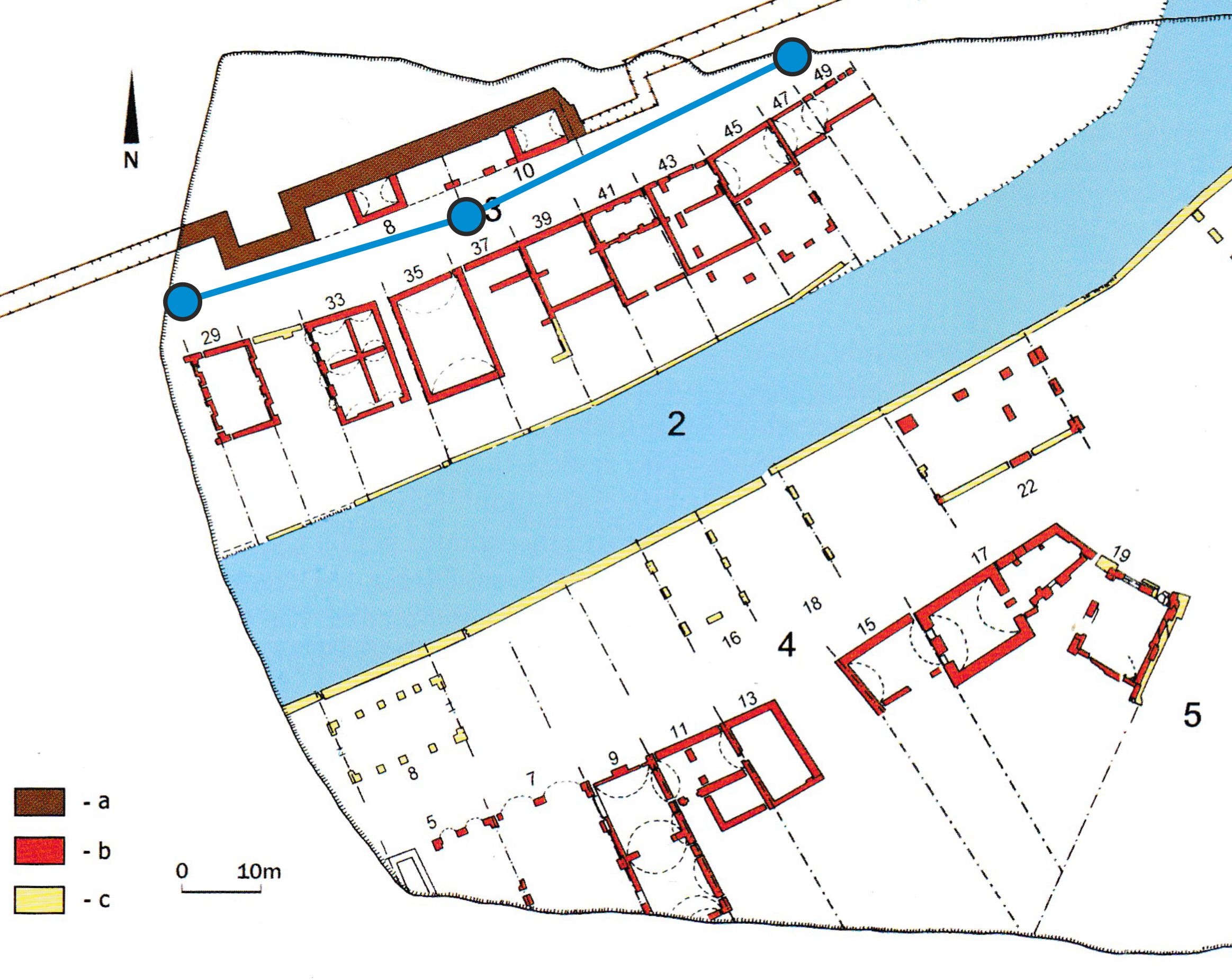
- Fig. 7. Course of a main water conduit with three water storage reservoirs on Zaułek Niski street (not existing) with surrounding plots. Excavated area under today’s Galeria Dominikańska shopping mall in Wrocław. Base plan: Konczewski, Paweł: Działki mieszczańskie w południowo-wschodniej części średniowiecznego i wczesnonowożytnego Wrocławia, Wratislavia Antiqua 9, Wrocław 2007, ryc. 7, p. 14.
Conclusion
In this paper we propose that the formation and existence of neighbourhoods in central European medieval chartered towns can be traced via certain features of the built environment, and that written records can complement our knowledge invaluably. We assumed at the beginning that the neighbourhood is based on face-to-face relations. According to M.E. Smith one of the indicators of the neighbourhood in archaeological sources is the clustering of houses. In the case of chartered towns, we can assume that a city-block is the cluster. Archaeological and architectural features indicate that relations inside the city-block changed over time. When a plot was loosely built-up it was easy to move and maintain face-to-face contacts on all sides of each plot. After erecting border-walls and larger buildings adjacent to borderlines, those face-to-face contacts with neighbours were reduced. Access to the property was possible from the front, and thus the street became an open space that could generate contacts. The growing importance of street space may be indicated by the stabilization of the street level (prohibition of littering) and the emergence of representative façades. The transitions that we observed (the diminished spatial connectivity within a city-block in particular) allows us to suppose that at a certain point, the street arose to become the most important area for maintaining social relations in a neighbourhood. We must also consider that meeting places other than the ones strictly related to the urban layout, which were the focus of the current paper, also existed within neighbourhoods (such as churches or taverns).
On the other hand, written sources emphasise that intensive contacts inside city-blocks were maintained through time despite the rise in infrastructural density. Even though physical contact was less feasible, neighbours had many points of common interest, fostering both negative and positive interactions. Town court books registered multiple conflicts over elements of infrastructure and buildings. Maintaining devices such as gutters and wells could not be effective without harmonious (financial) cooperation. Negligence by one neighbour could have had consequences for both plots, such as lack of fresh water, or no waste water removal. This continuing need for interaction built mutual and long-lasting relationships among neighbours. If we refer to Ferdinand Tönnies’ sociological concepts, we may say that this was the way in which permanent social relations were formed. Since neighbourhoods occupied definite space, we may call them territorial communities with a sense of group identity.
While many of the documents we mentioned here mainly refer to the owners of plots, who were in charge of maintaining common infrastructure, these plots were also home to many more people, such as the: owner’s relatives, previous owners who had the right to stay until their death (widows for example), tenants, servants, and people apprenticing under a master-craftsman. Neighbourly interactions were multidimensional and complex even within a single plot. An insight into such relations among neighbours-relatives within one plot in Krakow can be traced in a source from 1568. Several owners of one plot were reminded by building inspectors that they should keep the property clean especially in common areas. Another issue that we did not fully look at is the social stratification of inhabitants within a plot. One large house on a plot provided a shelter for people from the upper classes as well as tenants of different social origins (foreigners, students, the poor), alongside servants and workers. It was not the patrician or the artisan who was going to the public well to fetch the water, but rather a servant or journeyman from a workshop. Thus, neighbourly relations were also social status-dependent.
To conclude, territorial neighbourhood communities are reflected in the built and in social urban space. This certainly resulted from a natural need for efficient everyday functioning: relationships among neighbours constituted a basic element enabling the entire urban organism to act optimally. The neighbourhood primarily focused on maintaining its built environment for the upkeep of its living conditions. The material space created a framework for neighbourly relations, generating local identity, which moves us to the concept of neighbourhood not as spatial but rather social category.
Acknowledgments
The authors would like to thank Joanna Sudyka, Max Grund, and Maciej T. Radomski. The work on this study was financed by a Fuga 5 grant (2016/20/S/HS3/00084) from the Polish National Science Centre, awarded to P. Cembrzyński and supervised by U. Sowina, and by the ROOTS Excellence Cluster (Kiel University) funded by the Deutsche Forschungsgemeinschaft (DFG, German Research Foundation) under Germany’s Excellence Strategy – EXC 2150 – 390870439 where P. Cembrzyński is employed since 2019.